What the heck!
A Modest 2020 Update
September 23, 2020Modern Times and Multiple Hats
June 26, 2021Pease Press has a new website hosted by Wix.com, including an online store! Farewell to filling out a paper form and mailing it in with your check, hello online shopping carts, customer-entered credit card charges…new fees… I am late to the party but I am happy to be here now.
I created my original website 20 years ago using Dreamweaver (by Macromedia, then Adobe). There were things about it I liked a lot, but it required a lot of remembering and linking, and I had started to lose track of the format due to broken HTML or CSS links, not to mention “improvements” by Adobe (the text containers I used to make clumsy columns kept working, but the menu item to make them vanished in an upgrade because they were not best practice).
My old site was definitely not adapted to the big/screen/tiny screen era, but I couldn’t tell from Adobe’s templates if there was a dynamic format that would do what I wanted. (Sometimes I want to set a long list in columns, or the text next to the image, at least when possible). Knowing what I know, I should probably go back and do a little forensic reconstruction what parts of the Wix experience Dreamweaver can be set up to do. But really there’s no need to look back. Dreamweaver got me here, and I’m gratefully moving forward.
Wix has done a nice job of integrating a lot of moving parts into a fairly neat package. I was able to recycle a lot of my existing graphics, and (as advised by my wonderful partner) I copied the legacy text out of my Dreamweaver files into a Word doc, then paste the best parts into my new Wix pages. It was also a chance to drop a lot of legacy verbiage… turns out I was happy with half as many words.
In starting this transition, I also looked at Square Online, AKA Weebly. Several friends who run businesses jumped into online sales during COVID using Weebly, but when I tried to sign up in early 2020 they seemed overwhelmed (loading, loading, loading…nada). They may have worked out those kinks. I did a two-week test of Square Online in Spring 2021 and it was promising, but their store templates were eCommerce oriented from page one, or artful home pages for single-purpose businesses.
But at Pease Press we wear multiple hats – book publishing in partnership with my partner Shizue, self-published trail maps, selling my own maps and others, and the work that pays the bills – my freelance cartography, with samples of my work. Happily, Wix had at least one template that I could shape into into the landing page I needed; that says to all my potential customers “You’re in the right place for…” and where to click for the full book page, map store, and freelance map info.
In one week I got all my major maps and books set up in the store, ran some test purchases, refined the graphics, and redirected my URL to the new site. This week I continued to refine it, add flat maps and help publicize a book launch. It’s looking good enough, and working well enough, I can stop tinkering and get back to making maps for my customers (and mail books, do my bills, take us both on a short trip).
Crosstown Trail in Vis Valley
September 23, 2020Here is a little map I drew for the Crosstown Trail blog; fellow contributor Karen Rhodes wrote about restaurants and other attractions on San Francisco’s Leland Ave in Visitacion Valley for the first anniversary of Mission Blue Gifts & Coffee, and we were wondering what sort of map graphics work in WordPress (directly and as links).
- We can link to PDFs, but WordPress won’t let us put PDFs within the post, so I made a JPEG. Then… all that 6 and 7 point type reads poorly on screen. The red restaurant labels (the whole point of the map) don’t jump out. Clicking on it doesn’t zoom; it’s static. So it could stand a revision or two. And I’d better add another “s” to “Mision.”

Without shrinking the size (or enlarging the scale), I redid most of the Gill Sans labels in Helvetica Condensed (which reads better in the same width) , leaving only the “to notes” in Italic. I added a clearer title in the style of the Crosstown Trail handout map, and a little city locator. (We’ll be doing more of these for other neighborhoods). Here’s the second draft.
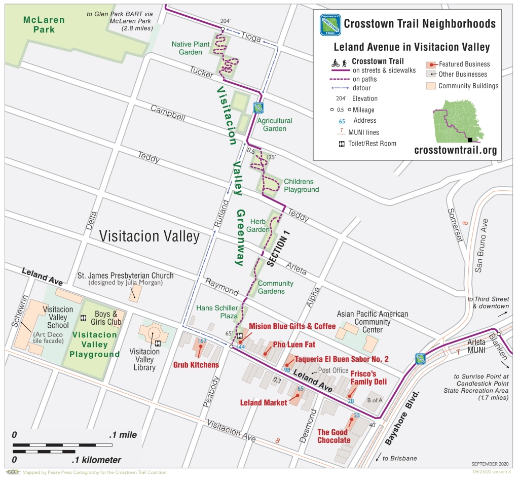
The full map is a little unfocused on the restaurants, but the Vis Valley Greenway is one of our most complicated and delightful parks, and we hadn’t mapped it at walking scale. Some of the nicest old (and new) buildings are just past where the trail turns. I cropped the JPEG that’s in Karen’s post so the restaurants are central.
Later, when we map the Richmond District, 19th Ave at Irving St, and Glen Park, there are good restaurants several blocks both east and west of the Crosstown Trail, so this is a promising format. We can also highlight scattered eats (for instance, in the 2.8 miles between Leland and Glen Park in Section 1, three grocery stores make custom sandwiches, and another has a burrito counter).
Happy exploring, and bon appetit!
A Modest 2019 Update
November 27, 2019I’ve been editing bits of the SF Crosstown Trail blog; I should probably update my own. I’ve been busy, I’ve been behind; I’ve been traveling, and also distracted by Facebook and politics.
In 2019 Pease Press updated the 4th edition of our Walker’s Map of San Francisco and the 2nd (or 12th) edition of Trails of Mt. Tamalpais, Muir Woods, and Marin Headlands. We had time to visit most of SFMOMA’s Take Part SF map exhibit at the San Francisco Library, and in the process we found lots of little details to fix on our San Francisco map. Street names are more complete, more landmarks are in the right place, and we fleshed out the text with more info on parks and neighborhoods. Brief but still worth having done. Writing to fill the available space, then editing down or nudging text to fit one more line, was a good process.
Guidebook work included Day Hiking Mount Hood and Day Hiking the North Cascades, for The Mountaineers Books (new editions still in production as of 3/18/20), and the 4th edition of the Bay Area Ridge Trail guidebook for Wilderness Press. (Maps are also on the Ridge Trail website). Two 2018 guidebooks: Day Hiking South Central Alaska, and Urban Trails Tacoma, also came out in 2019.
A fun project in 2019 was mapping the Crosstown Trail, the 17-mile route across San Francisco from Candlestick Point to Lands End. The city’s recreation and open space element of the master plan had laid out a number of “Green Connections,” mostly sidewalk planters, groundwater recharge projects and the like, plus several regional trails – the SF Bay Trail, Bay Area Ridge Trail, and California Coastal Trail – and the Crosstown Trail. Those regional trails have actual organizations behind them; the Crosstown Trail was a mystery, which ultimately several friends decided to solve; they formed a committee, devised a route, and talked it up with agencies and neighbors. Since the trail was in the city’s master plan, the big thing was to map it, write up directions, and put it online for the world to walk. (Having spent years of committee meetings and wandering to define the Bay Area Ridge Trail route through San Francisco back in my post-college days, I opted to lay low; I was delighted with the routes and solutions folks came up with based on their knowledge of their neighborhoods and local trails). I helped fine-tune the descriptions and map it on a reasonable number of pages, and the trail launched in June 2019. A great group project! Thanks to stories in the Chronicle and New York Times, plus assorted other websites, people are using it on a weekly basis and for the most part find it delightful and unexpected. (My 2019 San Francisco map took so long to finish the text, I had time to add the Crosstown Trail to it too).
I’m behind on beauty and order around the house and office; and clearing the decks enough to get busy writing and exploring. Had some good luck writing in boring hotel lobbies; with a little more cleaning, maybe home will be equally boring/inspiring.
In the last year or two, my partner Shizue Seigel has finished two more fabulous, funny, gorgeous anthologies by Bay Area writers and artists of color: Endangered Species, Enduring Values, and Civil Liberties United. I redid the Pease Press website so books have equal prominence. Shiz put together a lot of good readings earlier this year with the various authors! More to come in 2020 as (if) conditions permit.
– bp
Way More Mapping (and Dancing) than Blogging
August 15, 2015I must remember to write blog posts with no reference to things that just happened, or are about to happen, because either they do or they don’t, then I have to post something else new or correct what I though might happen. Which I should do. I mean how hard is it? It helps when I remember the password to the blog. It helps when I’m not depressed to think it doesn’t matter what I write. It helps to just do it (when the urge strikes). Free write!
Time keeps speeding along. Many years ago the amazing Afro-Hatian dance instructor at CCSF, Miss Watson, forbade us from saying “I don’t have enough time” because it sets up a mindset of lack. The corresponding direction (and/or contradiction) in Re-evaluation Counseling is to say (regardless of actual circumstance) “I have all the time I need” and see what thoughts come up. When not distracted by other philoosophical directions, my RC teachers also say “Decide, Act, Discharge.” After too many years of discharging/sessioning about what I want to do or can’t do or wish I could do, I have decided one good application of this philosophy is in dance, be it salsa, Zumba, obon, or dancing with my sweetie. Ain’t nothing like making order of, and internalizing, then sharing, semi-comprehensible dance steps, to get me to pay attention and just do it, feel the feelings later, or feel the feelings and do it anyhow. It’s been a year of dancing against my better judgement, and it’s been a really good year. I can take that dance class experience and apply it to the rest of my life. On a good day.
The salsa rueda classes we took this summer at ODC in the Mission District were good also for frequent partner trading – there is always something to be learned by the way each partner dances a little differently. But I sure do like the one that brung me.
To update the preceding blog posts, we’ve led three more Coastwalks, printed the third edition of San Francisco and Santa Cruz, and overhauled the Tamalpais map. Dad died. My Coastside 2nd edition is temporarily stuck at third base. And I’ve done a thousand maps for other people. Authors, editors, artists, land managers, the general public. Two more are due today, so I won’t say what else I’m planning to write, but I hope to be back.
Santa Cruz is Coming!
April 18, 2013We’ve been exploring odds and ends for the 3rd edition of Trails of Santa Cruz, which will be out in late Spring, 2013. The biggest additions will be the new multiuse trail through Pogonip. We discovered two pleasant loop trails in Twin Lakes State Park on the inland side of Schwann Lagoon, and remapped most of the trails in DeLaveaga Park. Like our San Francisco map, we’ll show shaded relief, shopping areas, and views. It was a pleasure just to rattle around in Santa Cruz and Aptos again from our base camp at the Knights Inn on Beach Hill.
The Walkers Map of San Francisco is having a good time and wishes you were here. Thanks to collaborator Susan Schwartzenberg, a big poster of the SF map is in the “Map Room” of the Exploratorium, which just reopened in its new home on Pier 15 (April 17, 2013).
If YOU would like a big wall map of San Francisco we have a supply of unfolded north and south halves which you can tape together. You’ll need a wall space 34 inches wide x 60 inches tall – no easy feet in this cluttered age of ours but maybe you’re a neatnik AND a geographer. I had to pick one and that’s why the house is filled with books and maps.
Meanwhile, back at the ranch, Shiz is wrapping up work on 2 dozen maps for a new book by Rebecca Solnit, Unfathomable City: A New Orleans Atlas. (UC Press, November 2013). My sole involvement, other than creating base maps, was the map for “39 Sundays” showing Second Line parade routes. It’s like a transit map where all the stops are bars and social clubs.
Another project this winter was to redo all the open space preserve maps for Marin County Parks. Started out just adding their new “hawk” logo but ended up restyling everything. The maps are bolder and cleaner than before with shaded relief. With 23 preserves spread across 20 maps, there are numerous times when changing one trail affected several adjacent maps. In the “everything old is new again” department, we are considering doing several large-format maps that cover the region (like the brochures done in the 1990s but with good maps).
Happy Trails!
Scouting Coastwalk 2012 – Sausalito
June 24, 2012")
Pedestrians and cyclists on Bridgeway in Sausalito. Coastwalk will stay 2 nights on Angel Island at the Quartermasters Warehouse, visible at the center of this photo.
Because San Francisco Bay has so many edges, every year our Coastwalk is a little bit different. For several years we walked from where we park the cars, up over St. Hilary’s Preserve and down to Tiburon in time for the Angel Island ferry, but it was too strenuous a start, and there were a few too many unmarked junctions. We have done some interesting one-time routes, such as an excursion along Alameda shoreline via the Harbor Bay Ferry, and strolls through Chinatown and along the Embarcadero. Even if the route doesn’t change on a given year, we might end up with different campground reservations than usual, and have to start with Angel Island rather than end there.
I’ve been leading San Francisco Coastwalk for more than 20 years. For most of the past dozen years, we’ve been doing some variation of two days in San Francisco and 2 nights on Angel Island. When we do walk across the Bridge, we usually head west from the Bridge on the Coastal Trail, staying at the Marin Headlands hostel. But in 2012, we are making our first-ever excursion along the Bay Trail through Sausalito. If you have a spare couple days next weekend, and want to join a San Francisco adventure with 1-2 dozen other intrepid explorers of all ages, there’s still time to sign up until mid-week. http://coastwalk.org/coastwalks/2012-golden-gate-family-walk/
Day 1 (Saturday, June 30) we meet in Tiburon and take the ferry to San Francisco, walking 6 miles to the Presidio. We’ll camp out at Rob Hill with a group of Anza Trail re-enactors and friends from the Ridge and Bay Trails.
Day 2 (Sunday, July 1) we get a ranger tour along the Presidio’s western edge, to the Golden Gate Bridge, then we cross the Bridge to Marin County. It’s early so it shouldn’t be completely full of tourists. Ducking under the Bridge we take the old service road down to Fort Baker, sneak along Horseshoe Cove and past the Discovery Museum, then along the new East Road sidewalk and into Sausalito. Generally speaking we won’t stop at any tourist shops or coffee houses, but we’ll take a good rest break/lunch stop near the center of town, and another break at the Bay Model. If all goes well we’ll bid farewell to the waterfront and houseboat docks at 3 PM sharp and saunter over to Marin City in time to catch the 3:22 #19 bus to Tiburon, and the 4:00 PM ferry to Angel Island. We’re camping overnight in the Quartermasters Warehouse at West Garrison, arriving just after the last performance of Odysseus. Today’s Odyssey is roughly 9 miles from start to finish — longer than I had planned on, but nearly all level and with several rest breaks.
Monday we romp on Angel Island including a visit to the Immigration Station Museum, and up over the top of Mt. Livermore, and free time before dinner (5-6 miles). Tuesday morning we pack up and head back to Ayala Cove for a Coastwalk brunch, then head home from Tiburon mid-day.
You bring your enthusiasm, energy, a day pack, and lunch each day. Tents recommended for Rob Hill; you just need a sleeping bag for Angel Island. We provide 1 breakfast, 1 brunch, 3 tasty dinners, guides each day, and we haul your gear from camp to camp. Pretty cool way to camp out in sight of the City. Join us if you can!
On my pre-walk last Sunday I encountered hundreds of bicyclists (both locals and tourists) making the trek to Sausalito — happily on Sunday they’ll be on the west sidewalk of the Bridge and after Fort Baker we’ve got sidewalks and they’ve got bike lanes. I found a bunch more restrooms I hadn’t put on my maps, and a few more hidden waterfront paths along the houseboat moorings. If you were going to do this walk as a day-trip on your own, you could have a really enjoyable 5-7 miles. There are several places to lunch or picnic in Sausalito, and several possible return routes to San Francisco (Golden Gate Transit from Sausalito or Marin City). Remember once you get to the north end of Sausalito it takes another 10 minutes to cross under 101 and reach Marin City Transit Center (a glorious name for two bus shelters behind the shopping center). Many bus lines run only come once an hour, but they run like clockwork).
< • • • >
2nd Edition of the Walkers Map of San Francisco published!
May 25, 2012
The 2nd edition cover shows the Batteries to Bluffs Trail above North Baker Beach, with the Golden Gate Bridge beyond.
As we start into summer, we’ve published a 2nd edition of our wildly popular Walker’s Map of San Francisco.
Changes for 2012 are few but useful. We added the Lower Historic Trail on Mt. Sutro, the Coastal Trail and overlooks on the west edge of the Presdio, and new trailheads opening soon in the Marin Headlands. We also added the Juan Bautista de Anza National Historic Trail route from Lake Merced to the Bridge, and little details like the restored wetlands at El Polin Spring.
For east of navigating, we updated MUNI routes and demolished the old Doyle Drive (don’t read this map while driving the new detour!). We also added more street names and stairways, and corrected a bunch of little items submitted by sharp-eyed explorers.
The new map is working its way into stores; you can find it in late May 2012 at Christopher’s Books (18th and Missouri), Thidwicks Books (Clement at 12th Ave), Dog-Eared/ Alleycat/ Red Hill/ Phoenix; Modern Times (24th and Alabama-ish) Green Arcade (Market at 12th) and Cliff’s Variety (18th and Castro). And of course direct from Pease Press. More locations soon.
We shifted the cover to the lower left corner so the two halves of the map fit together as a big wall map (roughly 48 x 34 inches!). We’ve got a limited number of single-sided, unfolded maps you can mount as wall maps (direct from Pease Press only).
Cowell-Purisima Trail opens near Half Moon Bay
August 26, 2011In late August, 2011, Peninsula Open Space Trust announced the opening of the Cowell-Purisima Trail south of Half Moon Bay, CA. This scenic trail begins off the existing Cowell Ranch Beach overlook, and extends 3 miles south along the blufftop. The southern trailhead is about a mile south of Purisima Creek and middle Verde Road, opposite Bob’s Produce Stand. The northern 2.1 miles of trail are closed on weekdays in the summer (June-September) so the farmers can spray the adjacent fields without endangering trail users; the southern 0.9 mile is open year-round. The trail is open to bicycles and hikers — no horses or dogs due to agricultural regulations. The entire trail from either end is about a 6-1/2 mile round trip.

Except for the well-used stairway down to North Cowell Ranch Beach, there’s no beach access allowed to the middle and southern beaches, which are protected as harbor seal habitat.

This stretch of coastal terrace rolls gently along the seaward edge of the farm fields. Two substantial steel bridges carry the trail across deep gulches vegetated in coastal scrub and near its midpoint the trail switchbacks down to a shorter bridge across Purisima Creek.
The land has been farmed for well over a century; POST’s conservation easements have helped stave off development pressure from nearby Half Moon Bay and hopefully will ensure the farm operations are viable for generations to come. The main ranch complex — several houses, outbuildings, and a white barn — is just north of Pilarcitos Creek. In early Fall, the northern 3/5 of the terrace was planted in brussels sprouts and beans; the southern 2/5 was fallow pasture and a dormant pumpkin patch.
The chance to wander this landscape at a walking pace offers a whole new perspective. You can look down on these pristine little crescent beaches at several points along the new trail, and gaze back at the hills. Pelicans and gulls fly just off-shore at eye level, coasting on the wind rising over the blufftops. We also saw a number of little songbirds and at least a dozen bunnies. The trail is distant enough from Highway 1 that traffic is hardly heard. The southern viewpoint has a glorious view north all the way to Pillar Point.
On our August, weekend visit there were dozens of people fishing on Cowell Ranch Beach, with carts for their fishing gear parked near the head of the stairs, plus picnickers. Its popularity also means the northern trailhead tends to fill up (with overflow parking on the east shoulder of Hwy 1 if you’re careful). At first we saw few people along the trail, but I’m sure as it gets to be known that will change.

Here’s how the trail looks added to my Trails of the Coastside map. Feel free to copy for personal use. I’m doing a 2nd edition of the Coastside map in mid-2012 (If you have an old map and would like a page of stickers to add the new trails early, drop me an email at the Pease Press website). – bp
")
Map of Cowell-Purisima Trail near Half Moon Bay, CA
Invisible City: a San Francisco Atlas is on 99% Invisible
December 17, 2010One of the joys of the last year has been collaborating with author Rebecca Solnit on maps for her new book, Infinite City: a San Francisco Atlas. We did 22 maps for the book, juxtaposing Buddhist sites and salmon streams; industries of the 1960s and bars open today at 6 AM; where scenes from Alfred Hitchcock’s Vertigo crossed paths with 19th century photographer Edward Muybridge (inventor of stop-motion photography), and so forth. We had a great time putting Rebecca’s ideas and Stella Lochman’s data on the map, then seeing how UC Press’s talented designer Lia Tjandra transformed our rough art into 19th century masterpieces, and also how the more than 2 dozen authors and artists tied the threads together.
The Atlas has been everywhere recently (even though it’s sold out of its first printing – new ones on the way by the end of December). Most recently this morning, on KALW’s marvelous little 5-minute broadcast “99% Invisible. Producer Roman Mars and Rebecca Solnit talked about two of Shiz’s maps: Death and Beauty (homicides and cypress trees throughout the city) and Treasure Map (49 places around the city we know and love, from WPA murals to buried ships and nesting herons). Roman’s December 13th blog post has images of two maps and a good portion of the intro text, plus a link to the podcast. Pease Press in a pPodcast!
